
Magnitude 6.2 earthquake in central Italy
24 August 2016
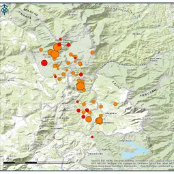
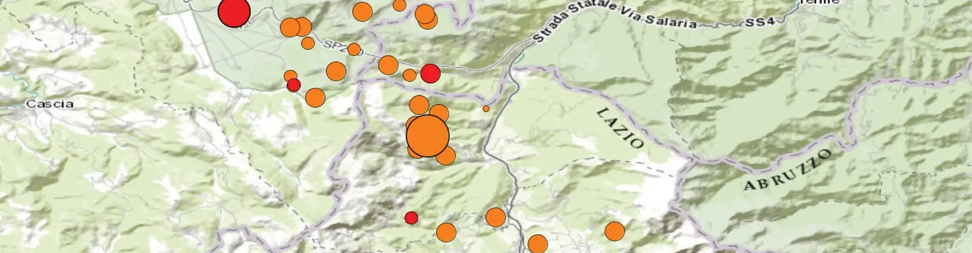
Early today, a magnitude 6.2 earthquake hit central Italy at 03:36 am local time (CEST). The epicentre of the earthquake was at (42.71 N, 13.22 E), according to the European-Mediterranean Seismological Centre. This is about 110 km northeast of Rome and about 35 km north of the deadly magnitude 6.3 earthquake that hit L’Aquila in 2009.
The earthquake was especially powerful due to its shallow depth: the Italian National Institute of Geophysics and Volcanology (INGV) indicates it happened at a depth of just 4 km. A number of aftershocks occurred in the hours following the main shock.
The earthquake took place within the well-known seismic belt, characterised by prevalent normal faulting, which runs NW-SE along the Central Apennines. The properties of the seismic source determined by major agencies for this earthquake suggest that the slip occurred along a NNW-SSE oriented normal fault (see for example, the INGV Database of Individual Seismogenic Sources database, which shows active faults in Italy). The source properties and the aftershocks distribution, appear so far compatible with the tectonics of the region.
The area experienced other destructive earthquakes in the past, including a M6.2 earthquake in 1639 and a M5.9 in 1646. The Rieti province was also shattered by the large Valnerina earthquake in 1703, which occurred with magnitude 6.9, according to information provided in the last release of the Italian Parametric Earthquake Catalogue. The most recent damaging earthquakes that affected this part of the Italian territory are the Assisi earthquake (1997, M6.0) to the north, and the L’Aquila earthquake to the south (2009, M6.3), both causing casualties and significant damage.
The area struck by the August 24 earthquake is characterised by a number of relatively small ancient towns, rather than by large cities. The worst affected towns are Amatrice and Accumoli. These towns are located within a high seismic hazard zone, according to the current Italian map; still, peak values of ground shaking as high as 45% of gravity acceleration have been recorded at some sites.
The United States Geological Survey gave an orange alert level for fatalities for this earthquake, indicating that significant casualties are likely. The estimated economic losses are high, as damage due to the disaster is likely to be extensive and widespread.
The Italian Civil Protection Service says that at least 38 people died and about 150 are missing. At about 3pm CEST, the Italian news agency Ansa reported over 60 deaths, though Italian authorities have yet to confirm this information.
The information above was compiled with the help of officers from the EGU Natural Hazards and Seismology divisions. Special thanks to Antonella Peresan, Earthquake Hazards Science Officer of the Natural Hazards Division, and her colleagues Damiano Pesaresi and Laura Peruzza at the Istituto Nazionale di Oceanografia e di Geofisica Sperimentale. More details about the earthquake will be added to this report as they become available.
Last updated at 15:15 CEST, 24/08/2016.
Contact
Bárbara Ferreira
EGU Media and Communications Manager
Munich, Germany
Phone+49-89-2180-6703
Emailmedia@egu.eu
EGU on Twitter: @EuroGeosciences
Links
- Summary from the European-Mediterranean Seismological Centre about the earthquake
- Special report from the European-Mediterranean Seismological Centre about the earthquake
- INGV page with updates on the earthquake (in Italian)
- Maps of ground shaking for this earthquake, provided by INGV
- United States Geological Survey event page
- Interview with Alessandro Amato, a seismologist at INGV, about the earthquake (in Italian)
- GFZ GEOFON Global Seismic Network