
Media highlights
You are viewing the EGU General Assembly 2024 Press Centre page. Click here to see information about media services and activities (e.g. press conferences) at the most recent General Assembly.
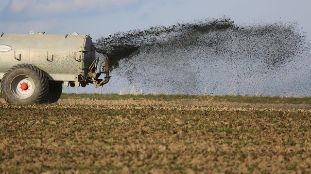
Enhanced weathering and rhizobacteria are a recipe for crop growth and carbon storage
Not only is industrial agriculture an extremely climate-intensive practice, it’s also subject to climate-induced changes like heatwaves and droughts. To address these concerns, farmers have sought out geoengineered solutions like Enhanced Weathering (EW)—e.g., spreading powdered silicate rocks to sequester carbon dioxide in the soil and increase essential nutrients like potassium, magnesium, and iron in soil—to varying degrees of success. Having previously investigated nutrient solubility in soil when a basalt-based EW was added to farmland, a bioscience engineering group from the University of Antwerp is now researching the addition of Plant Growth-Promoting Rhizobacteria (PGPR) to the rock powder to improve carbon sequestration and nutrient uptake rates.
By adding PGPR to areas already altered by EW techniques, researchers found chlorophyll levels to be increased, and plants showed higher photosynthetic activity. “This synergy has the potential to address the challenge of variable carbon sequestration efficiency and can provide a robust basis for improving crop health under diverse settings,” the team noted in their abstract.
To learn more about how rhizobacteria may increase basalt powder’s enhanced weathering effects, visit the research team’s poster on Monday, 15 April from 08:30–12:30 CEST in Hall X1.
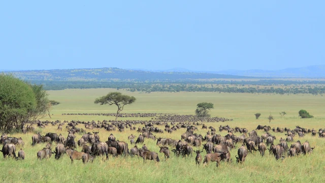
Satellites combined with machine learning track world’s largest mammal migration
Every year, millions of wildebeest, zebras and gazelles participate in the greatest show on Earth: a migration en masse across the vast plains of eastern Africa. Tracking wildlife across expansive landscapes poses immense challenges, but is important. To combat unprecedented global biodiversity loss, up-to-date data on wildlife populations is critical for implementing the most effective possible conservation strategies. Zijing Wu from the University of Hong Kong and a team of researchers have devised a deep learning pipeline for automatically detecting and counting migrating herds of wildebeest and zebra in the Serengeti-Mara region of Africa using satellite surveys and machine learning techniques. The team’s technique allows them to quickly obtain accurate population census data across open landscapes. The researchers say their deep learning process will “improve the conservation of the whole ecosystem in the face of rapid environmental changes.”
Learn more about how this tech-driven development offers new insights into animal migration behavior, as well as increasing the accuracy of wildlife monitoring tactics, during an oral presentation on Monday, 15 April from 12:10–12:20 (CEST) Room 2.95 as a part of Session BG9.1, which focuses on remote sensing applications for the biosphere.
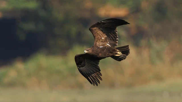
Conflict zones in Ukraine disrupt bird migration patterns
Large-scale armed conflicts pose significant challenges for society, from affecting access to basic goods, services, and resources to displacing entire populations of people. But the impacts of conflict zones aren’t just limited to human populations — anthropogenic disturbances can also affect local and migrating wildlife populations. The recent escalation of conflict in eastern Ukraine has had unforeseen consequences on wildlife migration patterns, particularly for long-distance migratory species like the Greater Spotted Eagle. New research led by Charlie Russell from the University of East Anglia sheds light on the impact of human conflicts on this species. As Russia invaded and conflict zones expanded across Ukraine, tagged migrating eagles faced unprecedented challenges and were forced to alter their behavior and migration routes with fewer stopover sites and a longer overall migration. These on-the-ground disruptions not only delayed their arrival at breeding grounds but also required more energy from the birds to get to their final destination. Russell and his research team offer a rare glimpse into the impacts of armed conflict on wildlife behavior, highlighting the need to better understand how conflicts affect the environment and how we might be able to implement future restoration efforts.
Learn more about how the warzone is altering raptor migration patterns in an on-site presentation from the researchers on Monday, 15 April at 15:25 CEST in Room 1.34. This session, ITS3.2, also includes presentations on additional geophysical impacts of armed conflicts.
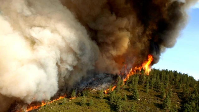
Examining the factors behind large wildfires
With the earth warming and regions becoming more arid, it feels like wildfire season is year-round these days. From cities burned to the ground in California and Hawaii to voracious bushfires in consuming hundreds of thousands of square kilometers in Australia and Canada, data show that fires are increasing in frequency and size all around the world. As global temperatures increase, so does the number of days per year with fire conditions. However, the nuances of the conditions that lead to large wildfires—climate, fuel, and weather conditions—are still largely unexplored.
According to Rebecca Scholten at the University of California Irvine, a disproportionate amount of the largest wildfires has actually been due to smaller fires merging. Cross-referencing satellite-derived datasets with photos from aircraft, the researchers examined extremely large fires in temperate and boreal biomes, hypothesizing that physical and human factors can accelerate this wildfire-merging, creating blazes that are more damaging and difficult to contain.
Learn more about the factors that make wildfires grow so large by viewing Scholten and her team’s poster on-site on Tuesday, 16 April during the presentation time, 10:45–12:30 (CEST) in Hall X1 for Session BG1.1.
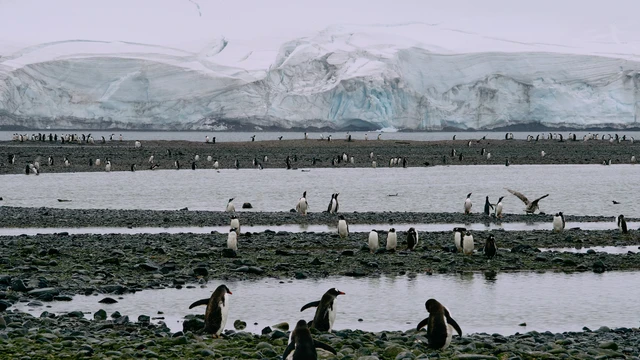
Penguin poop makes the Antarctic nutrient cycle go round
The few creatures that call Antarctica home are also responsible for critical nutrient cycling in the ecosystem. Adélie penguins, the key predators in this fragile ecosystem, spend much of their time hunting in the Ross Sea for krill but come to land to form colonies and raise their young. This time spent ashore has important impacts on wider the nitrogen (N) and phosphorus (P) cycles in the terrestrial Antarctic. As limiting nutrients, N and P are key factors in determining local ecology, from forming biological organisms to promoting primary productivity.
By comparing Antarctic soil and sediment samples taken from both penguin colonies and uninhabited areas, scientists led by Zhangqin Zheng of the University of Science and Technology of China identified just how crucial penguin bio-transport (i.e., guano) is in Antarctic nutrient cycling. Sediment samples from the most penguin-populous zones yielded higher concentrations of the nutrients, including forming of N- and P-rich minerals like struvite. The research further understanding of the N and P cycles in the Antarctic, a region undergoing changes due to the warming climate.
Learn more about how penguin poop affects the N and P cycles in Antarctica by viewing the team’s on-site poster Wednesday, 17 April from 14:00 - 18:00 CEST in Hall X1 (part of Session BG3.10).
One for the (history) books—digitized recordings of 1859 magnetic storm
Journey back in time to 19th century London, as researchers unveil the most complete continuous magnetic records of the infamous Carrington event, the most intense geomagnetic storm in recorded history. With data on the strength and direction of the Earth’s magnetic field first collected by the Greenwich and Kew observatories in the UK, the 1859 Carrington storm and the less-well-known precursor storm several days earlier were of unprecedented magnitude, with the greatest magnetic field variations literally off the charts—the magnetogram tracings went off the page.
A group of researchers led by Ciaran Beggan from the British Geological Survey has been hard at work to create digitized magnetic records of the 10 days surrounding the storms, bringing the data back to life by scaling the measurements to estimate the rates of change of the planet’s magnetic field as a result of the storms. Using images of original magnetograms and information from observatory yearbooks and scientific papers, the revamped historical data “demonstrate the good correlation between observatories and estimate the instantaneous rate of change of the magnetic field.”
Beggan and his team will present their research in person on Thursday, 18 April from 10:05-10:15 CEST in Room 0.51 as a part of Session ST4.4, which focuses on space weather and climate.

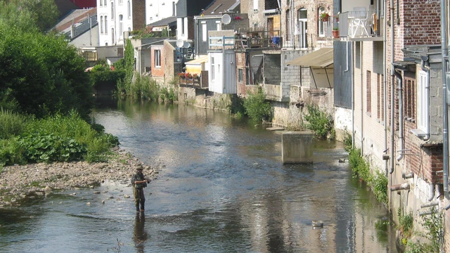
Buttertubs spilled during the July 2021 flood act as plastic transport tracers in the Dutch Meuse River
Rivers transport plastic pollution of all sizes, but macroplastics can be hard to track from source to sink because their point of entry into the riverine system is typically unknown. However, the July 2021 floods that affected several European catchments provided a unique opportunity in the form of about 8 million empty plastic buttertubs. A dairy company located along a tributary of the Meuse River flooded, and the millions of dairy packages floated downstream, each with an ID code that can be traced to their entry point into the river system. New research traces the path of these buttertubs over the course of two years to uncover how macroplastics travel downstream. The researchers found that the majority of the buttertubs were transported less than 100 kilometers within 20 days, with an average transport distance of between about 10 and 18 kilometers per day. During the next two years, the average transport distance dropped dramatically, to 0.23 kilometers per day. This suggests that in spite of the extreme flood situation, many of these macroplastics remained relatively proximal to their point of entry.
Learn more about how the buttertubs fared in a poster presentation on Thursday, 18 April from 10:45-12:30 CEST in Hall A, A.22. This session, HS2.3.5, includes a variety of presentations on the topic of plastic transport in freshwater systems.
Snowflakes or microplastics? Exploring the environmental consequences of snow storage
Whether it’s being pumped out of machines lining the runs or falling in fluffy flakes, the white stuff that makes ski resorts run is an increasingly hot commodity these days. Thanks to unpredictable weather patterns caused by climate change, more of the world’s snow sports destinations than ever are relying on artificial means to maintain their ski slopes. One such strategy, snow farming, has been employed by resorts in order to make sure they have enough snow on the runs to open at the beginning of the season. Snow farming entails covering the remaining snow at the end of the previous season with some kind of tarp—usually a geosynthetic—to stockpile it for the beginning of next year’s ski season. Despite the tarps being exposed to strong UV radiation and a wide range of temperatures on the slopes, little research had been done to quantify the release of microplastics from the geosynthetic tarps into the collected snow.
Concerned about the potential environmental impact of the covers, a team of researchers led by David Gateuille spent three seasons observing and quantifying the risk of microplastic particles emitted by snow farming tarps in use at Tignes, a popular ski resort in the French Alps.
The team’s results on the release of microplastics at ski resorts are significant. Learn more during the team’s hybrid presentation from 10:51-10:53 CEST on Thursday, 18 April. Part of Session ITS3.24/HS12.9 on plastic pollution monitoring, the button to access the Zoom meeting will appear just before the time block.

Fossils reveal Caribbean reef ecosystem changes amid predator loss
Vacationers and dive enthusiasts have long flocked to the Caribbean to see some of the world’s most vibrant coral reef ecosystems for themselves. But centuries of selective harvesting have caused lasting alterations to the food web, making it particularly difficult to understand the top-down processes in which predatory reef fish species regulate the abundance and body sizes of prey fish. Researchers took a deeper dive into the changing dynamics of predator-prey relationships in these marine habitats, referencing Holocene fossil, archaeological and modern fish remains to more accurately track changes in the abundance and body sizes of fishes in Caribbean reefs in Panama and the Dominican Republic over millennia. Predatory reef fish populations have declined significantly since human exploitation began, triggering a cascade of effects on prey species such as anchovies and damselfish. Once under constant threat, now, prey fish have experienced a surge in both abundance and size, while populations that are not subject to predation have been affected more by habitat and food availability. The findings offer valuable insights into the resilience of Caribbean reef fish species.
Learn more about their analyses of reef fish resilience in an oral presentation by Aaron O'Dea of the Smithsonian Tropical Research Institute in Panama on Thursday, 18 April at 15:10 CEST, Room 2.33. This session, SSP4.3, includes additional presentations on using fossilized records to make ecological inferences.

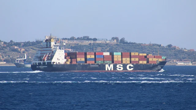
Container ships sparking changes in thunderstorm activity in the Mediterranean
From rough seas to customs complications to port infrastructure issues, container ships face a whole lot of challenges in making sure goods reach their customers. But a team out of Israel reports a shocking new development — in some parts of the world, ships are actually influencing thunderstorm activity.
Ship exhaust can cause atmospheric changes, including alterations in albedo and reduced precipitation. Now, using lightning detection network data and comparing it to how aerosols affecting lightning, Yoav Yair at Reichman University in Herzliya and colleagues have discovered that aerosols in the exhaust mix with desert dust to modify the microphysics of clouds in the busiest shipping lanes. The researchers observed the effects of ship-emitted aerosols on thunderstorms in the area between the Suez Canal and the Strait of Gibraltar—one of the busiest maritime transportation areas of the world—and noted that winter lightning activity over active shipping lanes in the Eastern Mediterranean featured larger and stronger bolts.
Meet the researchers and learn more about lightning and ship-tracks in an on-site poster on Friday, 19 April 08:30-12:30 in Hall X4 for Session NH1.5.