
Media highlights
You are viewing the EGU General Assembly 2023 Press Centre page. Click here to see information about media services and activities (e.g. press conferences) at the most recent General Assembly.
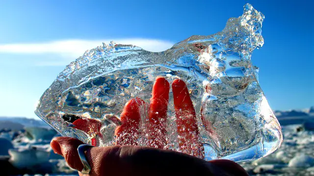
How and when did Earth’s first continents peek above early oceans?
The first emergence of continental crust above sea level marks a momentous episode in early Earth’s history. As those first rocks interacted with the atmosphere, everything began to change. But when did this happen, and how?
Priyadarshi Chowdhury , a geologist at the National Institute of Science Education and Research in Bhubaneswar, India, will present results that suggest that continental crust emerged between 3.3-3.1 billion years ago as a result of progressive crustal thickening driven by granitoid magmatism. As this early crust thickened and matured (chemically speaking), isostasy may have led to the continents’ rise above sea level without the need to invoke plate tectonics. Chowdhury will present these findings on Monday, 24 April at 14:00 CEST in Room 2.47/48.
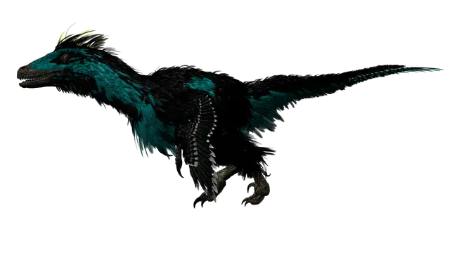
Familiarize yourself with feather evolution in dinosaurs
Open up an old book about dinosaurs and it’s easy to see how reptilian they look. None have feathers. But a new book about dinosaurs will astound with the variety of plumage in the illustrations. Over the past few decades, more and more discoveries have shown that feathers were quite widespread in the dinosaur world, much as they are in the bird world today. They were also quite diverse.
Pierre Cockx and Michael Benton, both of the University of Bristol in the UK, have been examining the evolution of feathers and feather functions in dinosaurs and early birds. Much as modern birds have different feathers that serve different purposes — such as stiff, strong flight feathers on their wings or soft, downy, warm feathers on their bellies — so did dinosaurs. Stiff, strong flight feathers have also been found on some dinosaurs, like on the legs of Paraves, theropod dinosaurs including Deinonychus and Velociraptor. But dinosaurs also seemed to have some feather types not seen in modern birds, according to Cockx and Benton.
Learn more about dinosaurs and their feathers in an on-site poster on Monday, 24 April, from 16:15-18:00 CEST in Hall X4.
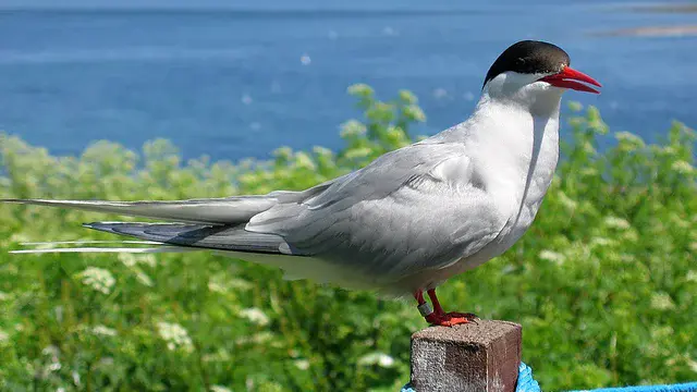
Birds that breed in Arctic summers likely affected by extreme weather
Migratory bird species in the Arctic depend on the short yet productive polar summers. An increase in climate variability — not just average changes, but more extreme events like heatwaves and excess snowfall — can result in lower reproductive success, and possibly death of these birds. For instance, in a warmer climate, snow is expected to decrease, and may result in more nesting areas, but snowfall variability is also expected to increase, resulting in unpredictable nesting conditions from year to year.
Nomikos Skyllas, a climate scientist at the University of Groningen, the Netherlands, will present model results using climate variables like temperature, precipitation, snow cover, primary productivity, solar radiation, and soil moisture at four different levels of carbon dioxide at timescales of 500 years. Skyllas will also discuss the effects of the predicted changes on migratory Arctic birds. This presentation is on Tuesday, 25 April at the poster session in Hall X5 from 10:45-12:30 CEST.
Angela Croome Award Lecture by veteran BBC reporter Jonathan Amos
From carbon copy paper to AI: what might it be like to have a 36-year career at the British Broadcasting Corporation (BBC)? From his early political reporting aspirations to becoming a full-fledged science reporter, Jonathan Amos shares his journey and experiences that led him to be one of the leading faces of science news globally. Amos was part of the team that first set up the BBC News website in 1997. His online reporting focuses on the Earth sciences, with a particular interest in the changes taking place in polar regions. He is also known for his coverage of European space activities.
Join us for this much-anticipated lecture by the Angela Croome Award winner on Tuesday, 25 April, 15:05–15:35 CEST in Room N1 on the green level.
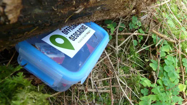
Treasure hunts lead to learning
You’ve probably heard of geocaching, the popular treasure-hunting activity that has people following GPS, and sometimes clues, to discover a hidden box filled with trinkets. (If you take a trinket, you’re supposed to leave one of your own as well.) The real fun is in the search and discovery, though, not the treasure. Now a team out of WasserCluster Lunz – Biologische Station, a nonprofit research center in Austria, says they’ve created a similar treasure-hunting game that can be used to educate the public about the natural environment.
Lake Lunz is a popular tourist attraction in Lower Austria. The only natural lake in the area, it is enjoyed by swimmers, sunbathers, and visitors who walk its shoreline. The team set up a series of questions about freshwater biology, the ecology of alpine lakes, and climate change that lead participants around the lake to a final destination treasure box. It is a “playful way for people of all ages to discover nature,” they say. And it’s a program that’s reproduceable anywhere. Learn more about biogeocaching on Tuesday, 25 April, in an on-site poster presentation from 16:15-18:00 CEST.
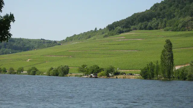
Shocked wine: How volcanoes and climate affect harvest quantity
Wine is a climate sensitive crop, with most studies focusing on wine grape harvest date to gauge the relationship between climate and grape growth. However, researchers led by Fredrik Charpentier Ljungqvist, a historian at Stockholm University, Sweden, instead focused on wine harvest quantity, examining two sets of records from the Moselle Valley in Luxembourg. They found that extremely cold or wet years affected wine harvest quantities, and that volcanic forcing events resulted in larger declines — or even total harvest failure. Wine production, they found, declines for several years in the aftermath of an eruption’s effects, though the first year after the event bears the brunt of the impact.
Ljungqvist will also discuss a comparison of how well wine production quantity correlates with tree ring growth. This presentation is Tuesday, 25 April at 17:30 CEST in Room 0.31/32.
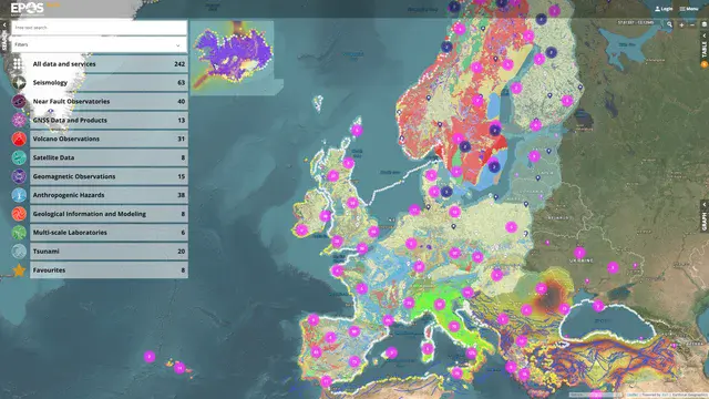
Introducing: the EPOS Data Portal to access multidisciplinary scientific data in Earth dynamics
EPOS, the European Plate Observing System, is the only research infrastructure for solid Earth science in Europe. Over the last twenty years, an international team of 600 experts has worked in synergy on the integration and harmonization of over 250 types of data and services, with the aim to foster research and innovation. The results of this huge community effort will be presented for the very first time on Tuesday, 25 April at 19:00 CEST in Room E2 on the yellow level, where the EPOS Data Portal will be officially released.
The Data Portal is expected to help researchers and national governments in identifying tools for mitigating natural hazards, as well as promoting investments in research and innovation. Participants of EGU23 will also be able to see the results of this commitment by visiting the EPOS stand, using the Data Portal, and attending the presentation of case studies developed by young researchers.
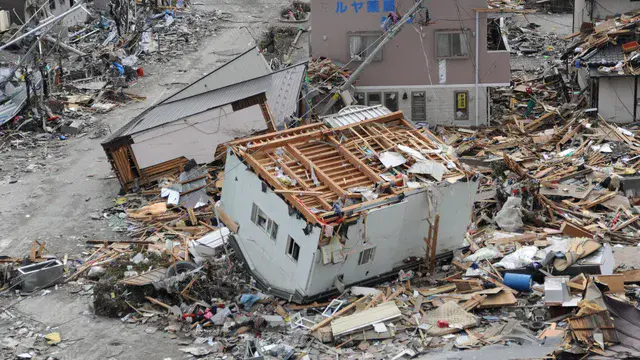
Garbage after a natural disaster can be a disaster itself
Earthquakes, tsunamis, hurricanes, floods, landslides, and other natural hazards can produce significant waste after striking human settlements. The equivalent of tens of years’ worth of garbage filled landfills after the Kobe earthquake in 1995 in Japan, for example. In the wake of the 2010 Haiti earthquake, which killed some 220,000 people, a cholera outbreak killed another 10,000 people, in part due to sanitation issues from lack of waste infrastructure. One research team says it is important to think about this waste, preferably before the next natural disaster strikes.
Most urban systems, like water management, electricity systems, and transportation, are considered “critical infrastructures,” and have plans in place for keeping them running or getting them back up and running quickly in the face of a disaster. But historically, waste management has not been considered such a system, thus it hasn’t been given much thought. Researchers from Gustave Eiffel University in France argue that waste management has many similarities with other critical infrastructure and should be afforded the same emergency planning and management.
Learn more about their proposal to include waste management in post-disaster critical infrastructure planning in an on-site poster presentation by Gaïa Marchesini on Wednesday, 26 April from 10:45-12:30 CEST in Hall X4.
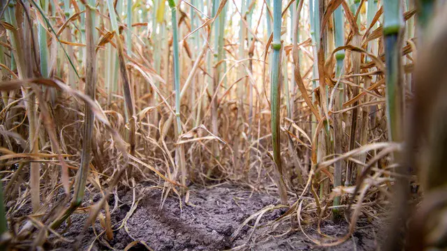
Why you should care that our subsurface soil moisture is changing
The soil root zone is the area below the soil surface in which plant roots take up water and nutrients. Without the proper amount of moisture — not too little and not too much — in the soil root zone, plants will not survive. Without plants, animals and people won’t survive. So to say root zone moisture management is important is quite an understatement. New research suggests, however, that root zone soil moisture has already been permanently changed in parts of the world due to global warming. And it’s going to change even more over the next 25-75 years.
The team’s models suggest that the Mediterranean, South Africa, and parts of North and South America will become permanently drier in the years to come. In the Mediterranean, for example, the researchers found the soil root zone has already become significantly drier. Meanwhile, Northern Africa and Southern Asia will become permanently wetter. The changes are coming quickly, the team notes: Root zone soil moisture will become permanently altered in more than 25 percent of global land as soon as 2050. The team will report their research on Wednesday, 26 April, at 10:51 CEST.
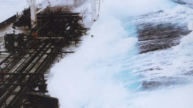
Waves gone rogue: how to predict an ocean scourge
Rogue waves are unusually large waves at the ocean’s surface that can be extremely dangerous to even the most massive ships. They seem to appear out of nowhere, with a wave height more than twice the significant wave height (the average wave height of the highest third of waves). These single, giant waves gone rogue can capsize ships, damage offshore structures and harm beach-goers.
Though models can predict the average behaviour of ocean waves, such models cannot predict the height of individual waves. Any rogue wave prediction method will instead be probabilistic, meaning that models can provide information about where these waves are most likely to occur.
Recent studies suggest that certain variables strongly correlate with rogue wave probability, so if those variables can be predicted, rogue wave probability can be ascertained. Johannes Gemmrich, an ocean physicist at the University of Victoria, Canada, will present results focusing on one variable — the crest-trough correlation — that can be forecast with moderate accuracy. By including predicted significant wave heights, Gemmrich’s team can identify regions of enhanced rouge wave risk. These results, as well as a case study of a large storm off Canada’s west coast, will be presented on Wednesday, 26 April at 14:15 CEST in Room L3.
Working to protect Europe’s heritage one building at a time
The built heritage across Europe is subject to natural hazards. For example, the 2,000-year-old Gaziantep Castle in Turkey was demolished by the devastating Turkey-Syria earthquakes in February. It is not just earthquakes that threaten buildings: Floods (like the one in summer 2021 in Central Europe), wind storms, fires, and even acid rain also imperil Europe’s built environment. Researchers are working to help cities make the best decisions to preserve these renowned structures.
One such project aims to determine how hazards like earthquakes, floods, and fires can be responded to, while accounting for local cultural differences. A team out of Romania, led by Maria Bostenaru Dan of Ion Mincu University of Architecture and Urbanism in Bucharest, want to help scientists determine the best way to help cities prioritize retrofit options. They started their work by looking at seismic retrofit options for famed Art Nouveau and Modernism buildings in Eastern Europe. They will present a virtual poster on their findings and how this program can be expanded on Thursday, 27 April, from 08:30-10:15 CEST.

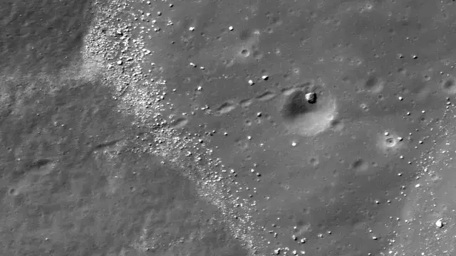
Lunar “rolling stones”
Boulders litter other planetary bodies. On the moon, “rolling stones” have left tracks that sometimes cover long distances. Typically attributed to either impacts or moonquakes, some scientists suggest that another possibility could be thermal-induced. In other words, the sun’s heat could be causing the rock to break down, delivering the initial momentum needed to start a rock rolling.
Artificial-intelligence-based mapping indicates that the majority of these boulders are not found within craters, but such methods could also be underestimating the total number of boulders with tracks. Planetary scientists Urs Mall, of the Max Planck Institute for Solar System Resarch, Germany, will present findings based on using spectral characteristics of the newly exposed regolith in boulder tracks, which should be distinct from the mature lunar surface through which these tracks thread. These first results, which should help disentangle likely causes for the rolling stones, will be reported on Thursday, 27 April at 15:57 CEST.
Permeable paving offers path to urban cooling
Impermeable surfaces, which tend to be associated with urban spaces, can prove problematic. For instance, storm surges can overwhelm sewers. Paved regions also tend to be hotter than rural areas, or even urban green spaces, exhibiting what’s called the urban heat island effect. Better infrastructure may hold the solution to these human-made problems.
In particular, permeable paving can provide a robust surface that helps to drain water, which solves the first problem. But can permeable paving mitigate urban heat? Adrian Butler, a hydrologist at the Imperial College London, United Kingdom, will present a detailed performance evaluation of permeable paving pads, in which they found significant cooling effects. With minor design modifications, permeable paving may mitigate urban heat impacts. This research will be presented on Friday, 28 April at the poster session in Hall A from 10:45-12:30 CEST.
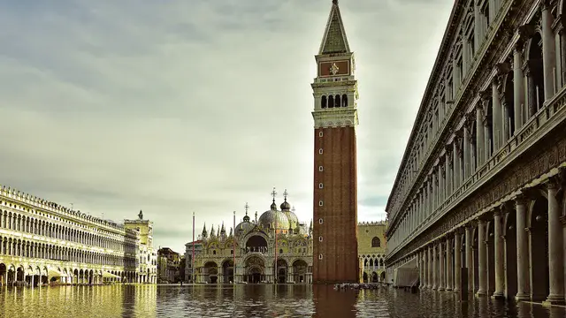
Pressures on Venice ecosystem grow, even as flooding decreases
Over the last few decades, Venice’s flooded sidewalks have become a familiar sight, with tourists wading through ankle-deep water to take pictures in St. Mark’s Square or sip coffee at romantic cafes. As Venice, and the lagoon along which the city is built, battles rising sea levels and sinking land, the region has become “the new paradigm of conflicts arising from the interactions among economy, society, and the environment,” according to Andrea D’Alpaos of the University of Padova in Italy and colleagues.
The Venice Lagoon is the largest brackish water body in the Mediterranean. It cannot be entirely cut off from the Adriatic Sea or it will become an algae-filled putrid swamp. But too much exposure to the sea will drown the city. Therein lies the rub: how to determine the right amount of water to let in through the city’s multibillion-euro seawalls to both preserve the lagoon and protect the iconic buildings and infrastructure on Venice’s islands. This is a similar conundrum facing coastal systems around the world as climate change and people increase pressure on these delicate and valuable ecosystems, D’Alpaos and his colleagues note.
Learn more about their analyses of Venice in a presentation by Andrea D’Alpaos, of the University of Padova in Italy, on Friday, 28 April at 12:20 CEST. This session, GM5.1, includes additional presentations on flooding and coastal ecosystems.
By the 1980s, ExxonMobil accurately predicted global warming
Climate projections by the fossil fuel industry have rarely, if ever, been assessed. A team of scientists set out to evaluate all available global warming projections documented and modelled by Exxon and ExxonMobil Corp scientists between 1977 and 2003. They found that most projections calculated in the 1980s accurately forecasted the warming of Earth and were consistent with independent academic and government models.
Find out more on Friday, 28 April, 16:20–16:30 CEST from researchers at the Potsdam Institute for Climate Impact Research; Institute of Physics and Astronomy, University of Potsdam; and Dept. of the History of Science, Harvard University.