
Media highlights
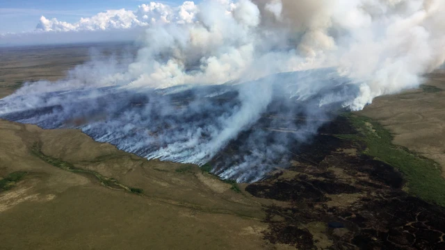
Is the future of civil engineering hiding in a rice paddy? A concrete solution, minus the concrete!
Crumbling bridges, roads, and buildings present a growing and costly challenge as infrastructure ages and climate extremes intensify. Repairing and replacing them typically requires using Portland cement, a carbon-heavy product whose industry is responsible for up to 8% of the world’s carbon dioxide emissions and an industry that’s proven hard to decarbonise. But researchers in India are testing a new low-carbon alternative cement product that uses industrial and agricultural byproducts—and it works even better than the original.
The product is made from blast furnace slag from steel production and ash from burned rice husks. The team tested how well the new material bonded to existing concrete, which is important for how repairs hold up over time. Then they subjected the repaired samples to different stresses to mimic real-world wear and tear. They found that the new material outperforms conventional mortars and Portland cement, showing stronger bonding and even greater resistance to cracking and moisture damage.
The findings point to a promising path for extending the life of infrastructure while cutting emissions in a solid example of a nature-based solution, which is a key priority as cities adapt to a changing climate.
Learn more in a poster by Sulaem Musaddiq Laskar and colleagues at Netaji Subhas University of Technology in New Delhi at the EGU General Assembly 2026.
The poster is available Wednesday, 06 May, 08:30-12:30 CEST, Hall A (A.137). Find more nature-based solutions throughout the poster session and in oral presentations that morning as well (Room 1.14).
Is it just me, or is it shaky in here? How the hot sky is messing with the big metal birds
(*written in Up-Goer Five, as is the abstract: Up-Goer Five is a style of writing that uses only the ten hundred most common words to explain ideas simply)
We often hear that flying helps make the world warmer. But what happens when a warmer world starts to change flying? People have been talking more about how a warmer sky will make more of the kind of shaking you can’t see or easily know is coming. But not many people have asked how planes may need to change to deal with that shaking.
This is not just about a rough ride for people on board. More shaking can affect how planes are built, how they move from place to place, how much fuel they use, and how safe they are. The people who design planes may need to think in new ways about how planes are made and how they are used, as the sky becomes less steady and big weather events happen more often.
Learn more about how a warmer world may change flying and the planes we use in a talk by Hui Ling Wong of Imperial College London at the EGU General Assembly 2026, Tuesday, 05 May, 16:22-16:24, PICO spot 1B PICO1b.2.
The talk is part of a session all based in Up-Goer Five language, a session on multiple important topics from why the Arctic is warming faster than other regions (“Why does the cold part of the world with water warm so fast?”) to a new satellite being used to measure solar radiation and reflection (“Long-time ground-ball-looker: A new space box that will help us understand how quickly our ground ball is warming”).
When rain falls too fast, poo-namis ensue: How real-time wastewater intelligence catches spills that rain gauges miss
When heavy storms hit cities like Philadelphia, Pennsylvania, sewers can’t keep up. The result: billions of gallons of untreated sewage and polluted storm water spill into rivers and streams each year: some 12.7 billion gallons in Philadelphia alone. It’s a global problem. In the UK, increasingly intense and frequent storms are putting a similar strain on aging wastewater systems.
New research from the University of Stirling points to a critical and often overlooked factor behind these failures. Analyzing a year-long dataset from more than 1,500 sewer overflow monitors across Scotland, researchers found that it’s not how much rain falls, but how fast it falls that overwhelms sewer systems. Bursts of high-intensity rainfall were the primary driver of sewer overflows in 2025, triggering spikes in pollution even when total rainfall wasn’t unusually high. The findings suggest cities may be underestimating the risks posed by more intense storms, raising urgent questions about whether existing infrastructure is built for the climate that’s already here.
Bridget Rusk and colleagues will discuss their findings in an oral presentation on Wednesday, 06 May at 09:15 CEST, Room 2.44. This session, HS5.4.2, includes additional presentations on urban water challenges. Related posters can be viewed on Wednesday, 06 May, starting at 14:00 CEST in Hall A.
Home is where the habitat is: Extraterrestrial habitats on Mars need sociologists and interior designers as much as rocket scientists!
As humans push into more extreme environments, from deep-sea stations to future habitats on the Moon and Mars, designing for survival is no longer enough. New research presented at the EGU General Assembly 2026 suggests that the real challenge is making these places feel like home. We’ll need chefs to make the food taste like home, music to soothe and entertain us, sports and games to keep us busy. And we’ll need architecture to not only keep us alive, but to support long-term human wellbeing.
A multidisciplinary team uses insights from architecture, psychology, engineering, and environmental science to explore what turns a shelter into a place people can truly live in. Key pieces include using local materials to reduce reliance on supply chains, designing spaces that support comfort and sensory experience, and embedding cultural and social elements that encourage connection and identity. These elements are essential for maintaining mental health, cohesion, and stability during long-duration space or underwater missions or in climate-stressed regions on Earth.
Mónica Alcindor from CIAUD Research Centre for Architecture, Urbanism and Design, Portucalense University in Portugal, will present the team’s framework for this new version of sustainable design on Monday, 04 May, 14:45 CEST in vPoster spot A, with an additional poster later that day at 16:15 CEST, vPoster Discussion vP.98
You can find further details on both the oral session and poster presentation here.

Is everyday friction turning your polyester shirt into a major health and environmental hazard?
We may love buying inexpensive, fun clothing, but it comes with a different kind of price: that polyester material is releasing microplastics into the air.
Polyester is a synthetic fabric made from plastic. It’s basically plastic spun into fibers to make fabrics. As polyester has become the dominant material in fast fashion clothing, scientists are also increasingly finding tiny plastic fibers called microfibers in the air. Scientists attribute these microfibers to polyester, released through simple, everyday actions like walking, as the fabrics rub and shed microscopic strands into the atmosphere.
Now, Valentina Höchtl and colleagues at the University of Vienna are investigating whether this constant microfiber shedding from clothing could be a major driver of airborne microplastic pollution. The team used models to trace how these fibers move through the air across Europe in both rural and urban areas and then linked them to real-world measurements.
Their findings could reshape how scientists understand the sources of microplastics in the atmosphere, and could raise new questions about human exposure to these particles through the air we breathe.
Concerned about what you might be breathing from your clothing? Learn more in a poster at the EGU General Assembly 2026 on Friday, 08 May 08:30-12:30 CEST, exploring the hidden environmental footprint of everyday clothing. Be sure to check out the rest of the posters in this session, including another on clothing microfiber release, one about phthalate emissions from incense, scented candles and perfume, and one about urban road dust in Vienna
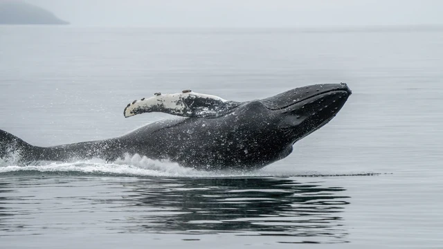
Whale, whale, whale, look who’s lost: New study reveals how anthropogenic activity is disrupting cetacean navigation
Humpbacks and other cetaceans have internal navigation receptors that are attuned to magnetic fields. In the past, researchers have noticed that magnetic disturbances, say from solar storms or human activity, have disrupted the ability of cetaceans to navigate. The result can lead to confused travel and even beachings.
In Iceland, the Ísafjarðardjúp fjord is a popular home for humpback whales. The fjord is also an active place for human activity, including fish farms, heavy ship traffic, and even the Bolafjall radar station. These marine activities cause magnetic interference, potentially interfering with cetaceans’ magnetoreception.
On Wednesday, 06 May, Asit Rahman of the University Centre of the Westfjords in Iceland will present a poster at the 2026 EGU General Assembly (16:15-18:00 CEST, vPoster Discussion, vP.25), and will give an oral presentation Thursday, 07 May (14:24-14:27 CEST, vPoster spot 2). Rahman surveyed the areas within the fjord that were most likely to have magnetic disruptions, the range of magnetic disturbances within the fjord, what human activities were responsible for the anomalies, and how these locations overlap with cetacean sightings. Rahman says the research should help guide policy efforts in the well-traveled fjord. Options for mitigating magnetic disturbances could include shielding submarine cables or restricting radar activities in vulnerable areas.
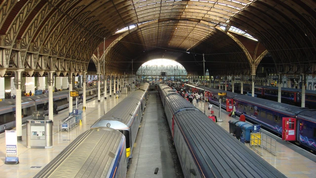
Off the (magnetic) tracks: Quantifying the impact of space weather on railway systems
Taking the train on holiday or riding the rails for your daily commute? Your on-time departure could be thwarted by space weather events.
Trains running around the world rely on interconnected systems that provide power, navigation, communications, and signaling. These systems often rely on the Global Navigation Satellite System (GNSS), a group of internationally owned satellites that link together to provide location information for anyone traveling via air, sea, or land. Space weather, often occurring as geomagnetic events, can disrupt these measurements and trigger issues in railway systems receiving GNSS information. The result can cause railways to experience incorrect signals, delays, or even potential collisions.
On Tuesday, 05 May at 17:00 CEST, Room -2.20, Cameron Patterson and Jim Wild of the Lancaster University in the UK will present their recent work on understanding how space weather impacts railway systems and what work needs to be done to help prevent these disruptions.
Check out the rest of the session (Tuesday, 05 May, 16:15-18:00 CEST) for more on solar storms’ effects on Earth.
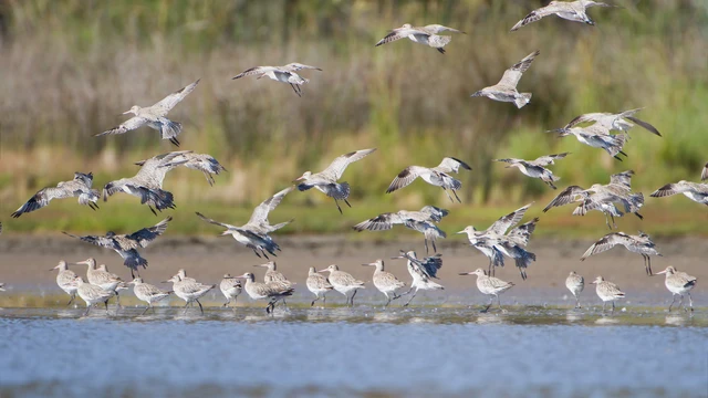
Is South Korea on to something? A new blueprint from a densely populated nation on how to hit global conservation targets without breaking the bank
Nations around the world have committed to the Kunming-Montreal Global Biodiversity Framework (GBF), pledging to conserve 30% of the planet’s land and seas by 2030. To meet these “30 by 30” goals, individual countries will need to balance the creation of new protected areas with the socioeconomic needs of their citizens.
South Korea is a critical stopover in the East Asian-Australasian Flyway, but currently, most protected areas are located in mountainous areas. Many migrating birds, however, flock to lower-lying regions, but habitats along coastlines, lowlands, farmlands, and islands are underrepresented. Increasing protected land in these areas can be fraught—often conservation goals are pitted against a push for land development.
Seungmin Lim and colleagues at Kangwon National University in the Republic of Korea wanted to identify areas in South Korea where ecological and socioeconomic realities can coexist. Using machine learning models that combined multiple ecologic factors with economic metrics, they identified which areas would offer high conservation value while creating manageable socioeconomic tradeoffs. On Friday’s poster portion of session ITS2.6/BG10.9 (Climate change impacts), the team will present their findings on site (14:00-15:45 CEST, Hall X1, X1.117) and explain how their approach can provide scientific support for conservation policy decisions.
Arctic fires are resurrecting millennia-old carbon sinks, and yes, you should care!
In recent years, wildfires have ripped across Arctic environments, burning boreal ecosystems. While aboveground vegetation burns, biomass stored underground is also destroyed. This carbon-rich soil took centuries to millennia to form and is not so easily replaced. Further, the nature and age of soil-based carbon released during these fires is not well understood.
In this timely session on the role of fire in Earth systems (BG1.1), Meri Ruppel of the Finnish Meteorological Institute and colleagues will present their work on understanding the age of carbon released during boreal fires. They collected charred organic material in Greenland and Canada and found that centennial- to millennial-aged carbon was released in these Arctic and boreal wildfires. They also conducted combustion experiments with biomass-rich soil layers from Svalbard, Russia, Norway, and Finland and found the combustion mode (and related carbon emissions) was directly related to the age of the material. Aboveground vegetation tends to flame while belowground organics smolder, emitting long-lasting carbon to the global climate system.
The results suggest that increasing Arctic wildfires may be exacerbating global warming more than previously thought.
Ruppel will present the findings Tuesday, 05 May at 11:15-11:25 CEST in Room N1.
Is your drive into Yosemite Valley a game of chance? New 3D simulation identifies the exact road segments where rockfall risk peaks
The sheer, granite cliffs make the scenery at Yosemite National Park in California, USA, breathtaking. But these iconic features can also be a danger as exfoliating slabs of granite sluff off the cliffs and tumble below where visitors roam.
Researchers wanted to better understand the rockfall hazards along three roads in the park: El Portal, Big Oak Flat, and Wawona. They combined rockfall data from 1857 to 2023 along with detailed information on risk factors of the slopes above the roads. These factors included things like slope topography and type of rock material, as well as traffic characteristics like vehicle numbers and occupants. Using a simulator tool, the team then evaluated the roads in 10-meter segments to evaluate the risk.
Their poster, which Rebecca Bruschetta of the University of Milano-Bicocca in Italy and colleagues will present on Friday, 08 May (14:00-15:45 CEST in Hall X3, X3.5) as part of the Mass Alpine Movements Session (NH3.5), shows several critical road sections where hazards and exposure levels are high. Their work identifies specific factors at each location that elevate risk. The researchers note this work will help park staff to mitigate rockfall risks within this mountainous, much-visited region.

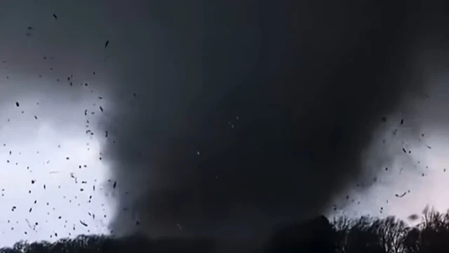
Tornadoes in 3D: How flying lumber and debris reveal the hidden physics of invisible winds
The nature of tornadoes is chaotic, and details about how they behave can be obscured by flying debris. For the first time, researchers have recreated the nature of tornadic winds by observing and mapping flying debris.
Roger Wakimoto of the University of California Los Angeles used photographs, high-resolution video, and mobile Doppler radar to capture an EF1 tornado as it entered Selden, Kansas, USA, on 24 May 2021. As the tornado moved across the land, the debris cloud remained transparent, allowing Wakimoto to get a clear view of the speed and orientation of lofted debris.
The circling wind revealed maximum horizontal velocities at lower levels, while the strongest vertical velocities were found on the forward side of the tornado. Wakimoto will present his findings, such as that wood boards that were lifted into the air seemed to have a preference for being oriented vertically, on Tuesday, 05 May, as part of the AS1.7 session on severe convection weather events.
Let's crack open a cold case, shall we? How 1960s beer caps are solving the marine plastic mystery.
Plastics in nature break down into random sizes and patterns. This chaotic disintegration leads to confusion on how different plastic particles are transported and how the pieces interact with ecosystems. While laboratory experiments and modeling have tried to predict fragmentation processes, real-world examples are rare.
Now, researchers have uncovered a natural laboratory to help trace plastics in the wild. Dollemard, a coastal landfill in Normandy, France, has given the team a plastic marker to trace throughout its lifecycle: polyethylene caps from VALSTAR beer bottles. The caps were thrown out in large quantities between the 1960s and 1990s. Because of coastal erosion, the caps are being released and found in adjacent marine environments.
Sébastien Rohais of IFPEN in France and his colleagues looked at more than 100 caps, noting signs of advanced degradation. In their poster on Thursday, 07 May (10:45-12:30, Hall X4, X4.50), the team will present that they found surface ablation and micro-fragmentation are the main processes that break down the caps over time. They also discovered that UV-rays affected particle sizes at larger millimeter scales, but not at the microplastic scale range. Learn more about what this “natural” laboratory tells us about how plastics break down in this poster session.

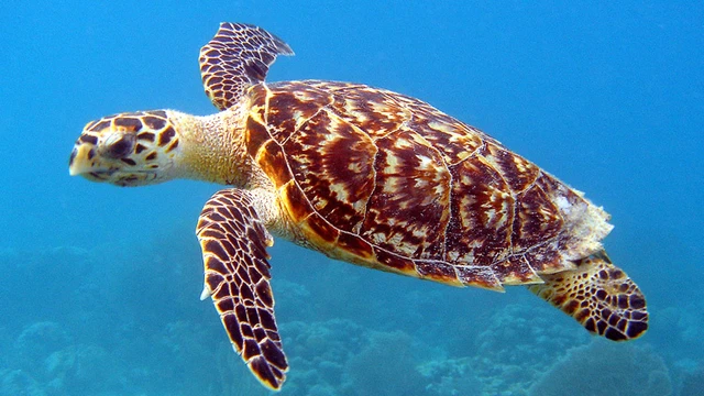
Can sea turtles shift their schedules faster than Earth's warming? Assessing the global feasibility of nesting phenology shifts.
Sea turtles face mounting threats from human activity, including overfishing, pollution, and habitat loss. Add rising ocean temperatures to the list. The sex of hatchlings depends on temperature, with warmer sands producing more females, raising concerns about long-term population collapse and possible extinction.
One possible lifeline: changing when they nest. Female sea turtles typically return to the same nesting sites where they hatched. So getting them to switch locations to cooler sites is unlikely. A different potential behavioral change is to shift egg laying to cooler periods of the year, helping to balance sex ratios. But could this phenological shift occur quickly enough to save turtle populations?
Previous research suggests sea turtles can adjust their timing by about one month for every 1.5°C increase in sand temperature. Building on this, researchers analysed 48 nesting sites worldwide to estimate how quickly turtles could shift their nesting under moderate (2–4.5°C) and extreme (5–8.5°C) warming scenarios.
They found that under moderate warming scenarios, turtles in the southeastern U.S. and eastern Mediterranean sites may need to adjust by the middle of this century. Sea turtles nesting closer to the equator have longer to adjust, by the end of this century or so, but likely have less to gain by shifting because of less seasonal temperature variation. Under more extreme warning, how long would sea turtles have to adapt? Learn more as Sandro F. Veiga and Huiling Yuan of China report the details of their work at the 2026 EGU General Assembly on Friday, 08 May at 09:45-09:55 CEST in Room 2.24. Be sure to check out the rest of the session on climate change impacts on ecosystems (ITS2.6/BG10.9), which starts at 08:30 CEST.