
Lochaber Geopark
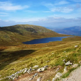
Lochaber Geopark covers 4648 km2 of the West Highlands of Scotland. We are a Scottish Charity organization, SC038372, based in a Visitor Centre in Fort William. Lochaber district has wonderful mountain scenery, including Ben Nevis, the highest mountain in the British Isles, and western coastline of exceptional beauty, including the magical Small Isles in the Sea of the Hebrides. We exist to promote understanding of the relationship between scenery and geology for our many visitors, and for local people, and to express the geological narrative contained in our exceptional range of rock types, ages and land-forms, from the Archaean to recent glaciation.
Lochaber’s geological highlights include the Glen Coe and Ben Nevis calderas and several large, composite granite plutons, including Strontian (home to Europe’s largest, but well hidden, granite super-quarry at Glensanda), Etive, Rannoch Moor, Ballachulish and Ben Nevis.
-5.1116 W, 56.8177 N