
Highs and lows: height changes in the ice sheets mapped
20 August 2014

Researchers from the Alfred Wegener Institute in Germany have used satellite data to map elevation and elevation changes in both Greenland and Antarctica. The new maps are the most complete published to date, from a single satellite mission. They also show the ice sheets are losing volume at an unprecedented rate of about 500 cubic kilometres per year. The results are published today in The Cryosphere, an open access journal of the European Geosciences Union (EGU).
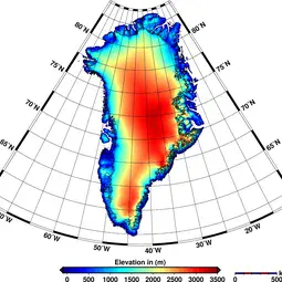
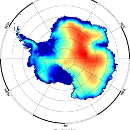
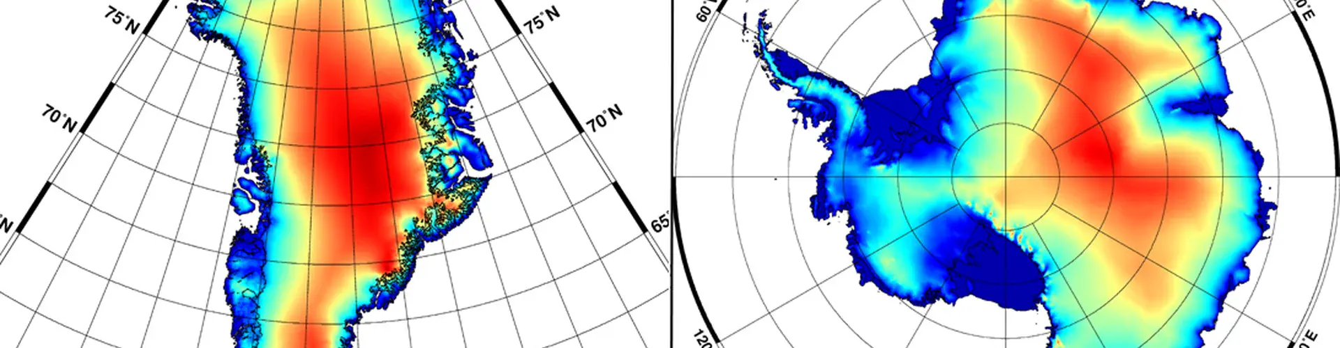
“The new elevation maps are snapshots of the current state of the ice sheets,” says lead-author Veit Helm of the Alfred Wegener Institute, Helmholtz Centre for Polar and Marine Research (AWI), in Bremerhaven, Germany. The snapshots are very accurate, to just a few metres in height, and cover close to 16 million km2 of the area of the ice sheets. “This is 500,000 square kilometres more than any previous elevation model from altimetry – about the size of Spain.”
Satellite altimetry missions measure height by bouncing radar or laser pulses off the surface of the ice sheets and surrounding water. The team derived the maps, which show how height differs across each of the ice sheets, using just over a year’s worth of data collected in 2012 by the altimeter on board the European Space Agency satellite CryoSat-2. These ‘digital elevation models’ incorporate a total of 7.5 million elevation measurements for Greenland and 61 million for Antarctica.
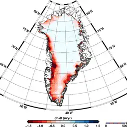
In addition to showing the highs and lows of the ice sheets at present, the study also highlights how the elevation has changed over the 2011–2014 period. Ice sheets gain mass through snowfall and lose it due to melting and accelerating glaciers, which carry ice from the interior of the ice sheet to the ocean. The researchers say it’s important to understand how ice thickness across Greenland and Antarctica has changed to model ice movements, and find out just how much ice sheets contribute to sea level rise.
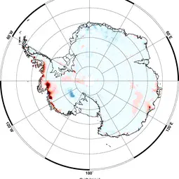
The team derived the elevation change maps using a staggering 200 million data points for Antarctica and 14.3 million for Greenland collected by CryoSat-2 over the three-year period. The maps published in The Cryosphere reveal that Greenland alone is reducing in volume by about 375 cubic kilometres per year. The two ice sheets combined are thinning at a rate of 500 cubic kilometres per year, the highest rate observed since altimetry satellite records began about 20 years ago. The researchers say the ice-sheets annual contribution to sea level rise doubled since 2009.
“Since 2009, the volume loss in Greenland has increased by a factor of about 2, and in the West Antarctic Ice Sheet by a factor of 3,” says AWI glaciologist Angelika Humbert, another of the study’s authors. Both the West Antarctic Ice Sheet and the Antarctic Peninsula, on the far west of the continent, are rapidly losing volume. By contrast, East Antarctica is gaining volume, though at a moderate rate that doesn’t compensate the losses on the other side of the continent.
The areas where the researchers detected the largest elevation changes were Jakobshavn Isbrae (Jakobshavn Glacier) in Greenland – recently found to be moving ice into the ocean faster than any other ice-sheet glacier – and Pine Island Glacier (PIG) in Antarctica. The new study confirms that PIG, like other glaciers in the West Antarctic, has been thinning rapidly in recent years.
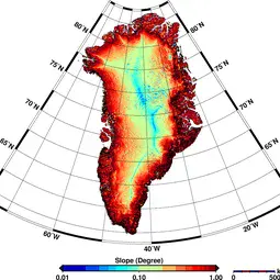
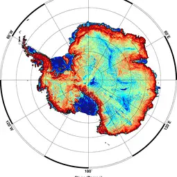
The researchers highlight the role of CryoSat-2 and its radar altimeter (also known as SIRAL) in producing the height maps, particularly in regions where the surface slopes steeply and elevation changes are more pronounced. “These areas can be difficult to measure, but SIRAL enabled us to continuously observe the surface of the ice sheets with high precision and dense coverage, better than any previous system,” says Helm.
###
Please mention the name of the publication (The Cryosphere) if reporting on this story and, if reporting online, include a link to the paper (http://www.the-cryosphere.net/8/1539/2014/tc-8-1539-2014.html) or to the journal website (http://www.the-cryosphere.net).
More information
This research, funded by the German Ministry of Economics and Technology, is presented in the paper ‘Elevation and elevation change of Greenland and Antarctica derived from CryoSat-2’ to appear in the EGU open access journal The Cryosphere on 20 August 2014.
Full citation: Helm, V., Humbert, A., and Miller, H.: Elevation and elevation change of Greenland and Antarctica derived from CryoSat-2, The Cryosphere, 8, 1539-1559, doi:10.5194/tc-8-1539-2014, 2014. Available online, free of charge, at http://www.the-cryosphere.net/8/1539/2014/tc-8-1539-2014.html.
The team is composed of Veit Helm, Angelika Humbert and Heinrich Miller from the Glaciology Section of the Alfred Wegener Institute, the Helmholtz Centre for Polar and Marine Research in Bremerhaven, Germany.
The European Geosciences Union (EGU) is Europe’s premier geosciences union, dedicated to the pursuit of excellence in the Earth, planetary, and space sciences for the benefit of humanity, worldwide. It is a non-profit interdisciplinary learned association of scientists founded in 2002. The EGU has a current portfolio of 16 diverse scientific journals, which use an innovative open access format, and organises a number of topical meetings, and education and outreach activities. Its annual General Assembly is the largest and most prominent European geosciences event, attracting over 11,000 scientists from all over the world. The meeting’s sessions cover a wide range of topics, including volcanology, planetary exploration, the Earth’s internal structure and atmosphere, climate, energy, and resources. The EGU 2015 General Assembly is taking place in Vienna, Austria, from 12 to 17 April 2015. For information regarding the press centre at the meeting and media registration, please check http://media.egu.eu closer to the time of the conference.
If you wish to receive our press releases via email, please use the Press Release Subscription Form at http://www.egu.eu/news/subscribe/. Subscribed journalists and other members of the media receive EGU press releases under embargo (if applicable) 24 hours in advance of public dissemination.
Contact
Angelika Humbert
Professor
Alfred Wegener Institute
Bremerhaven, Germany
Phone+49-471-4831-1834
Mobile+49-160-550-4427
Emailangelika.humbert@awi.de
Veit Helm
Senior Scientist
Alfred Wegener Institute
Bremerhaven, Germany
Phone+49-471-4831-1956
Emailveit.helm@awi.de
Heinrich Miller
Professor
Alfred Wegener Institute
Bremerhaven, Germany
Phone+49-471-4831-1210
Emailheinrich.miller@awi.de
Sina Löschke
Media and Communications Officer
Alfred Wegener Institute
Bremerhaven, Germany
Phone+49-47-4831-2008
Emailsina.loeschke@awi.de
Bárbara Ferreira
EGU Media and Communications Manager
Munich, Germany
Phone+49-89-2180-6703
Emailmedia@egu.eu
Links
- Scientific paper
- Journal – The Cryosphere
- Read this press release in simplified language, aimed at 7–13 year olds, on our Planet Press site