

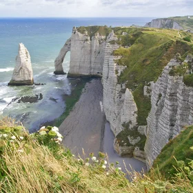
Chalk Cliffs of Etretat
From Imaggeo.egu.eu: http://imaggeo.egu.eu/view/1406/
From Geolog http://geolog.egu.eu/2013/04/29/imaggeo-on-mondays-the-chalk-cliffs-of-etretat: "Étretat is a coastal region in northern France, well known for its stunning geological landscape. Particularly the headland you see here. Headland erosion is perhaps one of the best known processes in coastal erosion, where a crack in the headland is opened and enlarged by hydraulic abrasion. Continued wave action causes the widened crack or cave to break through the headland and form an arch. As erosion continues, the arch collapses, leaving behind a stack (or needle) that erodes down to its base to form a much smaller stump. But that’s not all there is to Étretat, the chalky cliffs are composed of several layers, clearly distinguishable in Arrighi’s photo. These chalk layers are of varying hardness and can be clustered into three main strata: the lowest is a light, fine, stratified chalk aggregate, rich in foraminifera; the middle stratum is a compact chalk layer with beds that are tens of metres thick, and the uppermost stratum is composed of chalk nodules that, like the lowest stratum, is rich in foraminifera.
These strata provide insight into how the chalk of the region was laid down: the fine strata would have been a calcareous ooze, deposited by gentle currents and the nodular material would have formed as small “bullets”, before accumulating more calcareous material as they are transported and redeposited elsewhere. The sediments that now make up the Étretat chalk sequences were subject to several episodes of deformation and slumping before cementing to form the layered cliffs you see above."
0.2075 E, 49.7072 N