
Iraq–Iran earthquake: what we know so far
13 November 2017
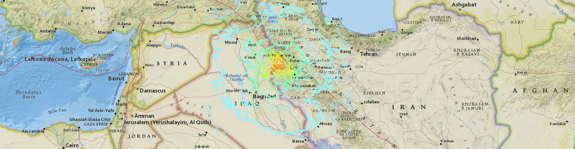
On the evening of 12 November, a magnitude 7.3 earthquake hit the Iraq-Iran border region. According to the European-Mediterranean Seismological Centre, the quake started at 18:18 UTC (21:18 local time) with epicentre at (34.79 N, 45.85 E) and a depth of 24 km. The epicentre is about 209 km northeast of Baghdad, Iraq, and 37 km north of Sarpol-e Zahāb, Iran, a city with a population of 51,700, which seems to have been particularly affected. As of 17 November, 430 people are confirmed dead, with officials estimating the death toll could be as high as 530, and over 7,500 were left injured. Aside from Sarpol-e Zahāb, most of the destruction is reported in the Qasr-e-Shirin city, also in the Kermanshah region of Iran.
A preliminary report by the International Institute of Earthquake Engineering and Seismology (IIEES) in Iran, shared by its lead author Mehdi Zare, Professor of Engineering Seismology at IIEES, reveals that:
“This event, that continued for 30 seconds, was felt in an extended area in Iran, Mesopotamia, the Caucasus, eastern Turkey, Iraq and Syria. Until November 17, 2017, about 345 aftershocks with magnitudes over 2.5 have been recorded by the Iranian Seismological Center. The largest magnitude of this earthquake’s aftershock sequence was 4.7, which occurred on November 13th.
The strong motion of the November 12, 2017, Mw7.3 mainshock has been recorded by 98 stations of the Iran Strong Motion Network. Among these records, the highest value corresponds to the station in Sarpol-e Zahāb with an uncorrected [peak ground acceleration (PGA)] of about 684 cm/s2. The corrected PGA values of the important records will be soon released in subsequent studies.”
(PGA measures how strongly the ground shakes during an earthquake; the Haiti 2010 earthquake, for example, had a maximum PGA of around 500 m/s2.)
The European-Mediterranean Seismological Centre highlights that the shaking caused by the 12 November Iran–Iraq earthquake was felt over a very large area, out to distances of over 1500 km in the United Arab Emirates even Jeddah, Saudi Arabia.
The faulting mechanism of this earthquake indicates thrust faulting, as a consequence of the Arabian plate moving northwards (with respect to the Eurasian plate) at a rate of about ~2.5 cm/yr. In the area of this earthquake, the plate convergence occurs along a northwest-striking plate boundary and is associated with the formation and uplift of the Zagros mountains (Iran), an area of frequent earthquake activity.
While seismic activity in the Zagros region in west Iran is high, the occurrence of such a strong earthquake in the northern Iranian part of the mountain range is somewhat uncommon. Mohammad Talebi, also of the IIEES explains: “The Zagros fold belt in the collision zone is responsible for most of the seismicity: magnitude <5.0 earthquakes in the Zagros region are frequent and magnitude 6 events may occur several times a year. However, the northern part of Zagros, including the zone affected by the M=7.3 earthquake, has lower seismicity than the southern part of it, and such a strong earthquake was not likely to occur where it did, according to an IIEES preliminary report.”
Mohammad Talebi also stated that the IIEES preliminary study reports that the M=7.3 earthquake had three foreshocks. The Temblor blog also reported on a magnitude 4.3 foreshock that preceded the main event on 12 November.
The United States Geological Survey highlights earthquakes that occurred a few hundreds of kilometres from the recent event, but not exclusively in the Zagros region, in the last 100 years: “Over the preceding century, the region within 250 km of the hypocenter of the November 12, 2017 earthquake has experienced 4 other M6+ earthquakes. The most recent of these was a M 6.1 earthquake about 100 km to the south of the November 2017 event in January 1967. (…) A M 7.4 earthquake in June 1990, 400 km to the northeast of the November 12, 2017 event, caused between 40,000-50,000 fatalities, more than 60,000 injuries, and left more than 600,000 homeless in the in the Rasht-Qazvin-Zanjan area of Iran.”
According to the IIEES, another historical earthquake of note in the region is a magnitude 7.6 tremor in Farsignaj, in the Kermanshah province of Iran, on December 13, 1957. It caused “heavy damages within an area of 2,800 square kilometers in which 1,119 people were killed and left 900 injured and 15,000 homeless.”
Resources
Damaging Magnitude 7.3 earthquake along the Iran-Iraq border was preceded by Magnitude 4.3 foreshock – Temblor blog
European-Mediterranean Seismological Centre (EMSC) information about the earthquake
United States Geological Survey event page
GFZ GEOFON Global Seismic Network information about the quake
News reports
Iran-Iraq earthquake: Hundreds killed as border region hit – BBC News
Iran-Iraq earthquake death toll climbs to more than 400 – The Guardian
Strong earthquake hits Iraq and Iran, killing more than 450 –
Reuters
We are grateful for input from Martin Mai (President, EGU Seismology Division), Antonella Peresan (Earthquake Hazards Science Officer, EGU Natural Hazards Division), Mehdi Zare (Professor of Engineering Seismology, IIEES) and Mohammad Talebi (PhD Student, IIEES). This report was last updated at 12:00 CET, 20/11/2017.
Contact
Bárbara Ferreira
EGU Media and Communications Manager
Munich, Germany
Phone+49-89-2180-6703
Emailmedia@egu.eu
EGU on Twitter: @EuroGeosciences